A paper published on 30 September 2026 in Molecular Ecology finds that eDNA (environmental DNA) collected by citizen seafarers provides high-quality scientific data, covering large areas of ocean at a scale traditional research expeditions can't match.
During the 2024 Pacific Rally, 27 vessels sampled eDNA from around 1.5 million km², an area that would cover New South Wales and South Australia combined (see figure 1). This was one of the most comprehensive eDNA baseline assessments of marine biodiversity in the open ocean, achieving much more extensive spatial coverage than traditional scientific expeditions.
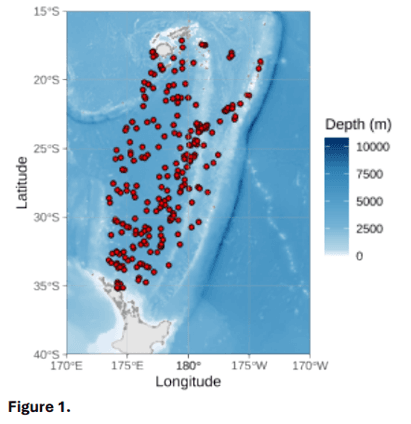
The researchers say the data gathered by sailors provides the highest resolution ‘picture’ of this part of the Pacific Ocean they’re aware of, to date. The paper confirms that citizen science research design can sample large areas of open ocean biodiversity comprehensively and affordably.
Most of our oceans are still biologically unexplored, especially in offshore and remote regions, because of the high costs and logistical challenges of traditional research expeditions. Filling this biological data gap would improve scientific understanding of complex ocean ecosystems, and how they are responding to climate change and other human-related stressors, such as pollution and overfishing.
“This work paves the way for a more powerful and repeatable approach to measure biodiversity change and ocean health across our rapidly changing oceans,” says senior author Dr Xavier Pochon, science leader at Citizens of the Sea, and Honorary Associate Professor at the University of Auckland.
Each participating crew on the 2024 Pacific Rally (6 May to 3 December 2024) was trained in a standardised sampling protocol and vessels were equipped with a TorpeDNA sampler, a device that collects seawater eDNA samples while the boat is moving at speeds of up to 12 knots. This generated 728 surface samples that were transported, chilled, to the Cawthron Institute in Aotearoa New Zealand for laboratory analysis under marine research permits secured for the Exclusive Economic Zones of Fiji, Tonga and New Zealand. Each sample was sequenced, identifying three types of organisms: bacteria, other single-celled life, and animals.
The result was 31,177 unique DNA sequences, providing a snapshot of the biodiversity within 20 degrees of latitude in the southwest Pacific Ocean.
The scale of sampling enabled researchers to evaluate the relationship between eDNA biological data and satellite-derived estimates of phytoplankton groups, for the first time. They found cyanobacterial taxa collected by eDNA sampling match satellite data reasonably well.
The most robust correlations were for the simple single-celled phytoplankton groups that satellites measure most reliably, with the lowest satellite uncertainty (prokaryotes, including cyanobacteria). The weakest correlations were for the more complex phytoplankton groups, which have the highest uncertainty in remote-sensing models (green algae, dinoflagellates and haptophytes).
This suggests that some mismatches may reflect current limitations in satellite-derived taxonomic classification. eDNA is not a perfect benchmark, but it provides an independent biological layer that can help interrogate, refine, and ultimately improve the precision of satellite-based biodiversity products.
To strengthen correlations, this research suggests that both satellite observations and eDNA collection should be refined. Tightening the onboard eDNA sampling protocol could reduce variation among samples that can be attributed to human and vessel differences. This would improve boat-to-boat comparability. As datasets collected by citizen science eDNA sampling become larger and less variable, they can provide representative reference data to help calibrate satellite models and reduce uncertainty.
The data also revealed a clear latitudinal gradient in marine biodiversity patterns, with communities shifting toward warmer tropical waters and generally lower chlorophyll-a concentrations. Earlier studies, without the sampling density of citizen science methods, found this pattern weak or absent.
This suggests that, over time, monitoring via citizen-science sampling could detect biodiversity shifts, changes to species range, invasive introduction, or climate-driven change.
Journal article
Saenz-Agudelo, P., Laroche, O., Knight, B., Bomati, E., & Pochon, X. (2026). Citizen sailors provide a detailed map of open-ocean surface biodiversity and help link eDNA data to satellite observations. Molecular Ecology, 35(19), e70571. https://doi.org/10.1111/mec.70571